Overview
For product information and Forecast API purchases, please see the Forecast API product page.
This page here and the following subpages contain all technical information about the Forecast API.
The meteoblue Forecast API enables developers and businesses to integrate reliable global weather forecasts directly into their applications and workflows. Built on meteoblue modelling and data-processing technology, the API delivers location-specific forecast data through structured endpoints designed for easy integration across industries such as energy, agriculture, finance, transport, and digital platforms. Detailed information about endpoints, parameters, request examples, and response formats is available in the full technical documentation.
Please refer to the Technical Documentation for complete technical details.
FAQs
How does the &asl parameter affect the weather forecast?
The &asl parameter specifies the elevation above sea level (in meters) for the requested location.
Elevation strongly influences weather forecasts because atmospheric conditions change with altitude. This effect is particularly important in complex terrain, such as mountainous regions.
If the parameter is not provided, the meteoblue API automatically determines the elevation using a digital elevation model (DEM) with a resolution of 80 meters. However, if the exact elevation is known, it is recommended to include it in the API request so that the forecast can be adjusted more accurately.
Changing only the elevation while keeping the same coordinates can significantly alter the forecast. For example, comparing forecasts for Sion, Switzerland, at valley elevation and at 3500 meters shows substantial differences.


Elevation corrections affect multiple forecast variables, including:
- Temperature
- Pressure
- Cloud cover
- Precipitation
- Wind
In mountainous regions, meteoblue high-resolution weather domains adapt forecasts to the surrounding terrain. As a result, a location in a valley can experience very different weather conditions compared with a nearby mountain peak, even when the geographic coordinates are identical.
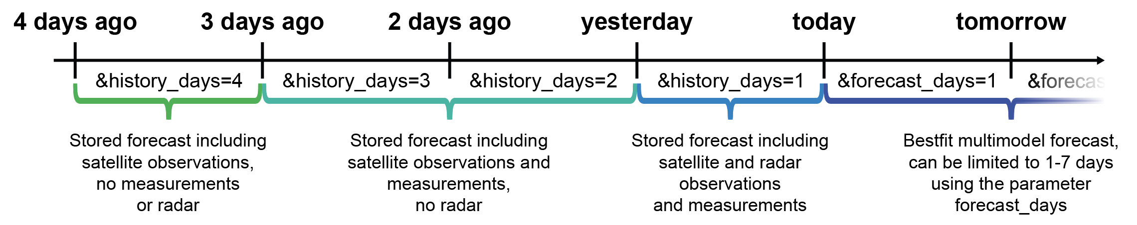
How is historical data from the forecast API composed?
The meteoblue Forecast API can provide past forecast data for up to 4 previous days using the parameter &history_days=
Historical data delivered through the Forecast API is not a simple archive of model output. Instead, it is progressively refined with additional data sources as time passes.
Depending on how far the requested data lies in the past, different datasets may be incorporated, including:
- Weather observations from ground stations
- Radar measurements for precipitation
- Satellite observations
- Numerical weather model output
- Post-processing and quality control
As time passes, forecast data is gradually enhanced or replaced by observation-based information, improving the accuracy of historical values.
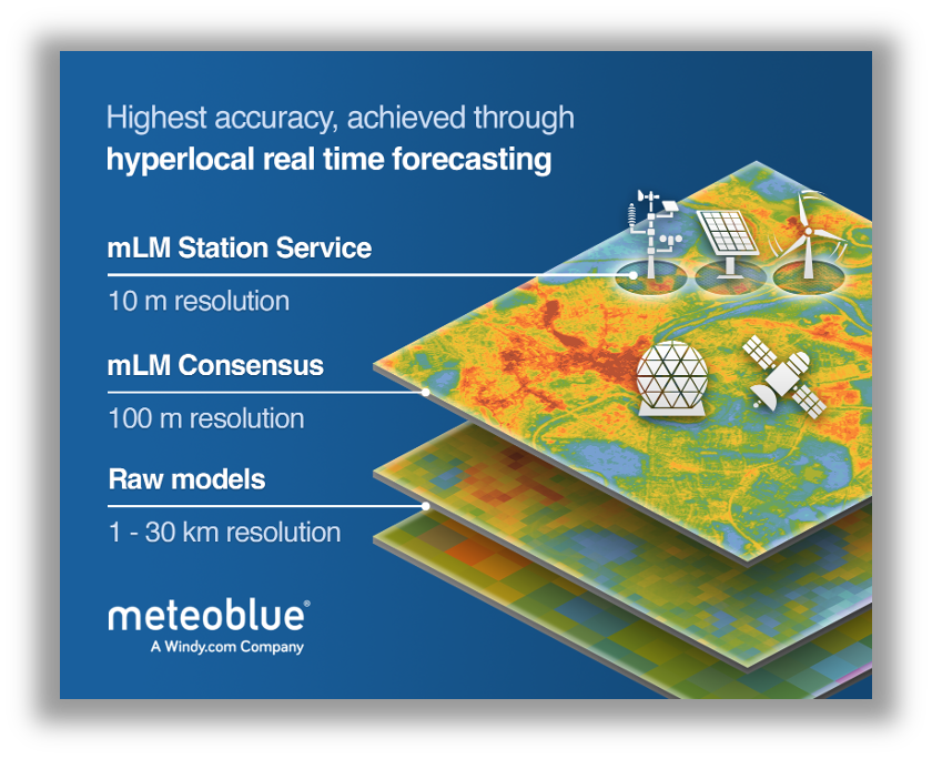
What is the meteoblue Learning Multimodel (mLM)?
Unless explicitly mentioned, meteoblue Forecast API packages outputs are based on the meteoblue Learning Multimodel (mLM) framework. The mLM is a post-processing technique that combines multiple numerical weather prediction (NWP) models with real-time data and machine learning.
Instead of relying on a single weather model, mLM dynamically evaluates the recent performance of all available models and selects the most accurate combination for a specific location. This evaluation is typically based on model performance over the previous 60 days, resulting in a location-specific model consensus forecast.
The framework integrates several data sources:
- Numerical weather prediction models
- Real-time meteorological observations
- Machine learning post-processing
- Radar and satellite data for nowcasting corrections
When local measurement data is available, the system can additionally train site-specific corrections, further improving forecast accuracy.
The resulting forecast is therefore not a direct model output, but a consensus forecast optimized for the requested location.
Are meteoblue forecasts grid-based or location-based?
meteoblue forecasts are location-based (point forecasts) rather than simple grid cell values.
When a request is made through the Forecast API, the system calculates a forecast specifically for the provided coordinates (lat, lon). The forecast is generated using the surrounding model grid data combined with terrain information, elevation adjustments, and the mLM post-processing.
This approach ensures that forecasts reflect the exact geographic location, even when the underlying numerical models operate on coarser spatial grids.
What spatial resolution do meteoblue forecasts have?
The spatial resolution depends on the location selection and underlying numerical weather models used within the mLM system. These models typically operate at resolutions ranging from a few kilometers to tens of kilometers.
However, because forecasts are processed with the mLM system and adjusted using terrain data and elevation, the API delivers location-specific forecasts, rather than raw model grid values.
This allows forecasts to better represent local terrain effects, especially in complex regions such as mountains or coastal areas.
How often are meteoblue forecasts updated?
meteoblue forecasts are updated whenever new numerical weather prediction (NWP) model runs become available.
Different weather models have different:
- update frequencies
- spatial resolutions
- forecast horizons
Global models typically update 2–4 times per day, while some high-resolution regional models may update more frequently.
The meteoblue Learning Multimodel (mLM) framework continuously integrates new model runs and recomputes the model consensus forecast. This means forecast values may change when new model data becomes available.
Because mLM dynamically evaluates the recent performance of multiple models, the selected model combination for a location may also change over time.
Also the MultiModel page shows when the models were last updated: https://www.meteoblue.com/weather/forecast/multimodel
Can I see which model run produced the forecast?
Yes. The Forecast API provides metadata fields that indicate the model run used for the forecast.
Important fields include:
| Parameter | Description |
|---|---|
modelrun_utc | The timestamp of the numerical model run used for the forecast |
modelrun_updatetime_utc | The time when the forecast data was processed and made available |
These parameters allow users to track when a forecast was generated and verify whether newer model data is available.
Why do forecasts sometimes change between API requests?
Forecast values can change for several reasons:
- A new numerical weather model run has been released
- The mLM consensus recalculated the optimal model combination
- New observational data improved post-processing
- Radar or satellite data updated short-term corrections
Because meteoblue forecasts combine multiple models and real-time data sources, forecast values evolve as new information becomes available.
Where can I find the available parameters and their units?
The Forecast API provides many weather variables, each with a specific parameter name and unit.
Because the available variables depend on the selected data package, the complete list of parameters and units is documented in the Forecast API technical documentation.
To see which variables are available in a specific package, refer to:
- the Package Overview
- the parameter tables for each package
- the API schema and response examples
For the full reference, see the Forecast API technical documentation where you can find:
- all available packages
- parameter names used in API responses
- units of each variable
- response structure and metadata fields
How is credit consumption calculated for Forecast API requests?
Each request sent to the Forecast API consumes credits from your meteoblue account, depending on the requested package and data volume.
Because credit consumption can vary between packages and configurations, the detailed rules are described in the Forecast API technical documentation and your **account usage overview.
In general:
- credits are consumed per API request
- the cost depends on the requested package
- requesting additional parameters within the same package does not necessarily require additional requests
To understand how requests and packages affect credit usage, consult the Forecast API technical documentation.
Your current usage and remaining credits can be monitored in the meteoblue user dashboard.